
GPS for Paddle Boarding: Routes, Speed, Safety, and Apps
Using GPS for paddle boarding turns every session into clear, actionable feedback.
A watch, handheld, or phone in a waterproof case can log routes, show real-time speed and splits, and provide a breadcrumb “back-to-start” for safer navigation.
Pair live location sharing with a simple float plan, and download offline maps before you launch.
For training, repeat short loops to benchmark pace, then use intervals and heart-rate zones to build fitness; A/B test fins or board setup by comparing average speed at similar effort.
Keep the device tethered, manage battery with airplane mode + GPS on, and carry a small power bank.
Most importantly, don’t rely solely on tech—know basic navigation, wear a PFD and leash, and tell a shore contact your plan. Start with the device you already own, and let the data nudge—not dictate—your progress.
Table of contents
GPS Devices for Paddle Boarding
You don’t need a pricey marine unit to get value from GPS on the water. A waterproof watch, a small handheld, or a smartphone in a dry case can all log routes, show current speed, and help you get back to your launch. On open water or anywhere unfamiliar, carry some form of GPS for paddle boarding —and a backup plan.
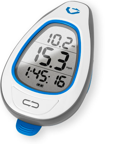
GPS Watches (the easiest option)
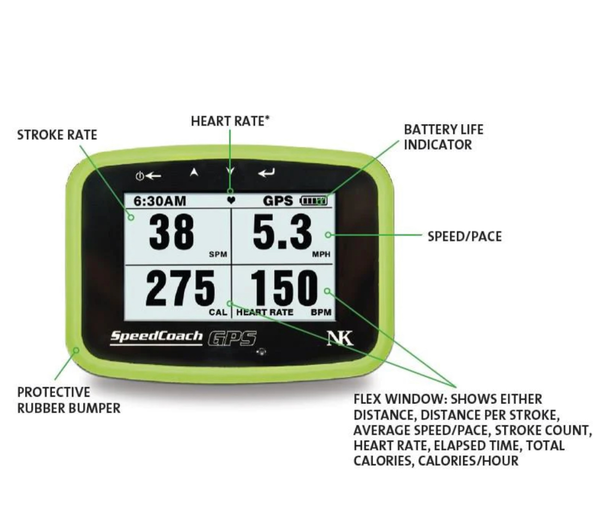
Lightweight and wrist-mounted, these track speed, distance, splits, and heart rate, with some models offering paddle-specific sport modes (stroke rate, stroke count, auto-laps). Battery life is usually enough for half-day sessions, and they’re the least fussy to operate on the water.
Handheld GPS Units
Great for long crossings and coastal runs. Bigger screens are easier to read in glare, buttons work with wet hands, and many support waypoint routing and breadcrumb “back-to-start.” Clip one to your PFD or stow it in a tethered pocket.
Smartphones (with a waterproof case)
Your phone + a quality waterproof case + a float/tether can do almost everything: log tracks, show offline maps, share location. Just manage battery (airplane mode + GPS on, lower screen brightness) and bring a small power bank.
How to Use GPS to Improve Your Paddle Board Skills
1) Route Tracking & Navigation
-
Drop a start waypoint at the launch and turn on track recording.
-
Sightline insurance: If fog rolls in or landmarks disappear, follow your breadcrumb trail home.
-
Route discovery: Save your best loops and share them with friends or your club.
2) Speed, Splits & Distance
-
Baseline pace: Paddle a familiar 1-mile (or 1-km) course in calm water.
-
Technique testing: Do 3–4 repeats, changing one variable (cadence, stance width, blade depth). Compare average speed and HR.
-
Wind awareness: Log upwind vs downwind legs. Aim for steady effort, not just raw speed, to sharpen pacing.
3) Safety
-
Live location sharing: Share a tracking link with a shore contact before you launch.
-
Back-to-start/nearest waypoint: Practice using it before you need it.
-
Float plan: ETA + route + who you’re with, and always carry a whistle and means of communication.
-
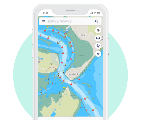
GPS Apps for Paddle Boarding (what to look for)
You don’t need a specific brand—just make sure your app has:
-
Track recording (GPX export is a plus)
-
Live location sharing
-
Weather/wind/tide layers or quick links to them
-
Offline maps so you’re not stranded without service
-
Data you care about: speed, distance, split pace; some add stroke rate using watch sensors
Pro Tips & Setup
Before You Go
-
Update firmware/app, download the map tiles for your area, and calibrate compass if prompted.
-
Create waypoints for launch, turn points, and hazards (shoals, piers).
-
Set auto-lap every 0.5–1.0 miles/km for instant feedback.
On the Water
-
Wear the watch on your top hand wrist for easier glance-downs mid-stroke.
-
Use data screens: (1) Current speed, avg speed, distance, lap pace; (2) Heart rate; (3) Map/crumb trail.
-
If using a phone, keep it tethered in a floating case; enable airplane mode + Bluetooth for watch sync to save battery.
After
-
Tag the session (flatwater, upwind/downwind, intervals), jot quick notes on conditions, and compare similar-condition days to track real progress.
Pairing GPS with Other Gear
-
Heart Rate Monitor (HRM): Combine speed + HR to build zones for aerobic base and threshold work.
-
Board & Fin Testing: Do controlled A/B laps (same course, same effort) to see which fin or board trim yields higher average speed.
-
Leash/PFD Storage: Some leashes and PFDs have secure pockets—stash a mini handheld or power bank there.
Note: Bluetooth trackers (e.g., lost-item tags) are not true GPS—they rely on nearby phones. Don’t treat them as safety beacons.
The Future of GPS on SUP
Expect richer stroke analytics, better wind/current overlays, and coach-style prompts (“cadence too low,” “inefficient yaw”). Cool—just remember the point is to enhance your paddle, not stare at screens.
Don’t Rely Solely on GPS
Batteries die and signals drop. Know your basic navigation: wind direction, shoreline features, sun position, and simple compass bearings. Carry a paper map or screenshot with key waypoints, plus a charged communication device.
Quick Checklist (copy/paste for your kit)
-
Watch/handheld/phone charged (≥80%)
-
Offline map downloaded + launch waypoint saved
-
Auto-lap set; live share link sent to a contact
-
Waterproof case + tether (phone/handheld)
-
PFD, leash, whistle, and a small power bank
-
Final Thoughts on GPS for Paddle Boarding
A simple GPS setup turns every paddle into feedback you can act on—safer routes, smarter pacing, cleaner technique. Start with what you have (a phone or watch), build a few go-to routes, and let the data nudge—not dictate—your progression.

Scott Knorp
Serial entrepreneur, passionate paddler, and co-owner of Glide.
FAQs
Do I need a special “SUP mode” on my watch?
No. Generic run/row/kayak profiles track speed and distance fine. SUP modes add stroke metrics—nice to have, not required.
Is phone GPS accurate enough on the water?
For most training and navigation, yes. For long coastal runs, pair a watch/handheld with your phone for redundancy.
What if I lose signal or my battery dies?
Know basic nav (wind, shoreline features, simple compass bearings), carry a whistle and charged communication device, and tell a shore contact your plan.
What metrics should beginners watch?
Distance, average speed, and lap splits. Add heart rate later to build aerobic base without over-paddling.
How do I test fins or board setup with GPS?
A/B laps on the same route/conditions at steady effort; the higher average speed with similar HR wins.


Sign up for paddleboard deals and tips!

